

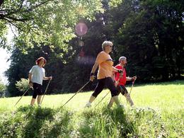


Upper Austria's first Nordic.Fitness.Park awaits you in Geboltskirchen
On four licensed Nordic Walking routes between 2.7 and 11.7 kilometers with different requirements and altitude profiles, you can enjoy the popular endurance sport in an optimal environment. All routes start and end directly at the family excursion destination coal station Scheiben. Good routing, varied terrain, different ground conditions and fantastic views make these 4 routes absolutely unique.Open all year round, free entrance.
By car:
Freeway:
On the A8 coming from Passau, exit Haag am Hausruck --> approx. 10 km to Geboltskirchen
On the A8 coming from Linz, exit Haag am Hausruck --> approx. 10 km to Geboltskirchen
Federal road:
Coming from Ried im Innkreis or Grieskirchen via B 141
by train:
Get off at the train station Haag am Hausruck --> approx. 4 km to Geboltskirchen
Please get in touch for more information.


")
")


