

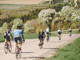
Trattnachtal Bike Path R17


- Possible accommodation
Interactive elevation profile
Create PDF
Tour-Details
Starting place: 4682 Geboltskirchen
Destination: 4070 Eferding
duration: 4h 21m
length: 65,9 km
Altitude difference (uphill): 239m
Altitude difference (downhill): 529m
Lowest point: 260m
Highest point: 637m
difficulty: medium
condition: medium
panoramic view: Individual Views
Paths covering:
Asphalt
powered by TOURDATA
This bike path runs for a distance of 69 kilometres from Geboltskirchen along the Trattnach to Eferding, where you can continue on the Danube Bike Path.
The Trattnachtal Bike Path follows the Valley of the Trattnach from its origins in Geboltskirchen via Weibern, Hofkirchen and Taufkirchen all the way to the district capital of Grieskirchen. Riding along the banks of the Trattnach, you then pass Schlüßlberg, Bad Schallerbach, Wallern and ...


Accessibility / arrival
by car:
On the A8 coming from Passau, exit Pichl.
On the A8 coming from Linz, exit Pichl
by train:
Vienna-Linz-Wels-Bad Schallerbach-Passau-Nuremberg-Frankfurt am Main
- Free entry
Most economical season
- Spring
- Summer
- Autumn
Please get in touch for more information.

Promenade 2
4701 Bad Schallerbach
Phone +43 7249 42071 - 0
Fax machine +43 7249 42071 - 13
E-Mail info@vitalwelt.at
Web www.vitalwelt.at/
Book now Book now
https://www.vitalwelt.at/
You can also visit us on
Visit us on Facebook")
")
)")
Interactive elevation profile
Create PDF
Tour-Details
Starting place: 4682 Geboltskirchen
Destination: 4070 Eferding
duration: 4h 21m
length: 65,9 km
Altitude difference (uphill): 239m
Altitude difference (downhill): 529m
Lowest point: 260m
Highest point: 637m
difficulty: medium
condition: medium
panoramic view: Individual Views
Paths covering:
Asphalt
powered by TOURDATA
